
Today we’re going to talk about world map biomes. If you’re new to the site, welcome, and if you’re a returning reader welcome back! This is a part of the long running series on the site concerning top-down worldbuilding to create your own large and varied world. The series has a specific bend towards fantasy tabletop RPGs like Dungeons & Dragons and Pathfinder, but has value for anyone interested in worldbuilding.
If you’re not caught up you can find an index of all the posts in the series HERE.
Why World Map Biomes are Important
In truth, it’s not. You can run most D&D campaigns slapping down forests, deserts, and plains wherever you like. Especially, if you’re not going to create a detailed map for the campaign world. Some of the most iconic fiction settings have nonsensical ecology such as the right angle mountain ranges around Tolkien’s Mordor. But, if you’ve been following along with this guide I’ll assume you see the value of creating a natural world that provides a certain level of verisimilitude to ease you and your players’ suspension of disbelief. Basically, the more your world seems like it makes sense in regards to how Earth works the easier it is to believe what happens in the world.
Our goal is to create a realistic representation of biomes in your world to make the world believable and seem real. Developing a thoughtful natural world can do just that.
World Map Biomes: Believable but Simple
What is provided in this blog is a distillation of the more complex process described in the Climate Cookbook. Unfortunately the link I had for the Climate Cookbook is long dead, but with some Google-fu you should be able to find a copy of it on the internet should you wish.

The Climate Cookbook is great, but it can be an unnecessary time sink in modeling climates for little effective gain. I want worlds to be believable, but I also don’t want to spend a lot of time tracking the effects of phenomena like the intertropical convergence zone (ITCZ) or the El Niño-Southern Oscillation cycle. That quickly reaches a point of diminishing returns for roughly the same end result.
Additionally, climate science is a living discipline where new research and theories are being developed about how Earth’s weather works all the time. I’m not trying to obtain an advanced sciences degree, I just want the forests for my elves to make sense when looking at a map.
Three Columns of World Map Biomes
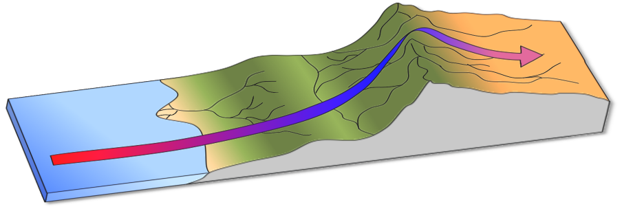
To the ends of making biomes for your world believable but simple, the whole process of top-down macro biomes can be distilled into three columns of biomes placed at different sections of your landmasses: East Coast, West Coast, and Continental Interior.
All of the worldbuilding climate can be simply distilled in this way because the major biomes are dictated by four very simple criteria:
- Latitude
- Distance from the Ocean
- Ocean Current Temperature
- Prevailing Winds
If you’ve been following along with this series, you’ll notice right away we have all this information. Assuming you did not make changes to any of this critical information such as planet size or the direction of prevailing winds and ocean currents you can apply the columns as written. If not, well you’ll have to put in some extra work to determine where your biomes should be placed.
Even if you didn’t make any large changes, you should still review the foundational criteria of your biomes to ensure you’re not missing important climate phenomena like the Gulf Stream, which makes Western Europe notably warmer than similar biomes at the same latitude.
For those following along with your map, the East Coast column always happens on the East Coast of a continent, mirrored North and South across the equator. The same is true for the West Coast column. The Continental Interior Column is only present in the center of continents and provides a gradient to help connect biomes on the East Coast and West Coast.* Thin continents will have a reduced Continental Interior Column or in some circumstances, none at all. Wide continents meanwhile will have a robust and relatively dry Continental Interior Column
- East Coast Column
- Continental Interior Column
- West Coast Column
*We will explore the Continental Interior Column with more scrutiny in the next post on biomes.
The Secret Fourth Column
There is also a secret fourth column for large landmasses. Landmasses larger than ~80 hexes (12 million square miles) will create a Monsoon East Coast similar to Southeast Asia. Other than a slight difference in forest biomes the Monsoon East Coast Column is very similar to the standard East Coast Column.
Implementing the Columns
In previous posts about the size of continents and landmasses we explored how large continents would have large plains and deserts. So if your world has large continents you will see a larger emphasis from the drier biomes of the Continent Interior Column and likely end up with the Monsoon East Coast Column.
If your map resulted with a bunch of small, snake-thin continents, there will be little-to-no Continental Interior Column providing many jungles and dense forests with few large plains or deserts in the world.
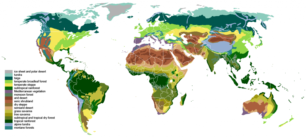
World Map Biomes Description
As humans living on Earth, most of these world map biomes are self-explanatory. You may have experience living in or visiting many of them. Regardless, here is a brief explanation of each major biome and where you can find references for the biome on Earth.
Icecap
Has the peculiarity of being composed of snow and ice and yet, receiving zero precipitation. It’s also the coldest and windiest biome. Best summarized as Antarctica, there’s no flora to be found. There are many types of fauna including coral, sponges, birds (including penguins), fish, crustaceans, seals, dolphins, and whales.
Tundra
Adjoining the Icecap this biome is cold and has very little precipitation (which falls as snow). Flora in the tundra includes twisted, dwarf trees (shrubs), grasses, and some perennials. You can find the real-world analogies on the Northern coasts of North America, Europe, and Asia. It can also be found on mountains above the timberline. Tundra fauna includes classic “winter” animals like snowy owls, arctic foxes, snow hares, and small vermin. There are also many hearty cold-water fish like cod, salmon, and trout.
Taiga

A belt of cold, evergreen forests also referred to as Boreal Forests. On Earth, this includes Alaska, Canada, Scandinavia, and Siberia. The soil is thin and drains poorly leading to the proliferation of wetlands, especially bogs (muskegs). The evergreen forests lack undergrowth shrubs and instead are covered by moss, lichen, and fungi. Other creatures include birds of prey, many bugs, and large land mammals (bear, deer, boar, large cats).
Tropical Forest
A belt of dense trees and undergrowth, tropical forests are what comes to mind when most people think jungle. They are hot, humid, and have high amounts of regular precipitation. Earth examples include the Amazon and Congo rainforests. This biome sports the widest diversity of flora and fauna. It’s dominated by crowds of trees competing for sunlight with dense layers of undergrowth and decaying plant material. Notable fauna include monkeys, large cats, tapirs, and tropical birds.
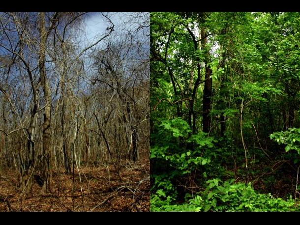
Temperate Forest
Thick clumps of deciduous trees with an understory full of shrubs and herbaceous growth. The temperate forest biome receives a heavy amount of precipitation throughout the year and hosts four distinct seasons. In fall and winter deciduous tree leaves change color and fall allowing more light to penetrate the understory, often along with snow. Notable fauna include wild pig, deer, raptors, foxes, wolves, and squirrels. For examples see Western Europe, American East Coast, and the Chinese East Coast.
Temperate Plains

Wide open seas of grass, hardier flora and trees often cluster around water sources as shaded oases. Temperate grasslands feature high winds, less precipitation, and a higher variance in temperature than forests, making them both hotter and colder. The soil is poor and ill-suited to agriculture beyond freshwater banks. The difference between a prairie and steppe are ambiguous. The most common distinction is a prairie features tall grass (wetter) while a steppe consists of short grass (drier). Notable fauna include herd animals, ground birds, and small rodents. On Earth you can look at the Great Plains of North America, the Eurasian Steppe, and the Pampas of South America.
Tropical Plains
Tropical plains of grass and isolated trees. Think of the Serengeti savanna and you know everything to expect from tropical plains. Daily temperatures are hot and often faced with harsh sun, and temperatures drop in the night more than the forest, but less than the desert. Like temperate grasslands, tropical savannas are prone to large grass fires in the dry months. Notable fauna include herd animals, herd-hunting predators, and freshwater fauna.
Tropical Desert
Tropical deserts are reminiscent of the Sahara with lots of sand, big dunes, and empty skies. Little flora survives in the shifting dunes and water is rare. Most fauna is nocturnal and consists of reptiles, bugs, small mammals, scavenger birds, and camels.
Temperate Desert

Temperate deserts, the iconic look of the American Wild West such as Monument Valley. Brush, cacti, and areas where the topsoil has been eroded away to create badlands with buttes and hoodoos. Temperate deserts can also be very cold in winter. Fauna includes small mammals, coyotes, scavenger birds, reptiles, and bugs.
Assigning World Map Biomes
The simplest way to assign biomes to your world map is by doing the universal latitudes first. The 0-6° North and South will be the Tropical Forest Biome. After that, 72-90° North and South will be Icecap. Everything at 60-72° N/S will be Tundra and finally, everything 54-60° N/S will be Taiga.
East Coast Column
The next world map biomes to assign is the East Coast Column. The East Coast is the simplest to fill out because it has no variation in biomes at any latitude. This is the same for East Coast Monsoon, which should be used on continents larger than 80 hexes in size. Follow the East Coast of your continents and potentially fill in one to two columns inward from the East Coast.
East Coast
- 72+ N/S Icecap
- 60-72 N/S Tundra
- 42-60 N/S Taiga
- 24-42 N/S Temperate Forest
- 00-24 N/S Tropical Forest
East Coast Monsoon
- 72+ N/S Icecap
- 60-72 N/S Tundra
- 48-60 N/S Taiga
- 36-48 N/S Temperate Forest
- 24-36 Temperate Seasonal Forest
- 12-24 Tropical Seasonal Forest
- 00-12 N/S Tropical Forest
Tropical & Temperate Seasonal Forest
These special world map biomes only show up in Monsoon East Coast Columns. The biggest difference in seasonal forests is many of the trees will shed their leaves to conserve water during the dry season. This break in the canopy allows light to reach the ground and provides these forests with thick flora in the understory and forest floor levels not present in non-seasonal forests.
West Coast Column
After filling out the East Coast Column, move to the West Coast of your continents. Filling out most of the column will be straightforward, but there are some places to make a decision. For example, the Chaparral biome only occurs at coastal hexes. Any West Coast Columns East of the coast will be Temperate Plains instead of Chaparral. Likewise, 6-18° latitudes will be Tropical Forest or Tropical Plains depending on whether it is on the coast and the distance from the East Coast.
West Coast
- 72+ N/S Icecap
- 60-72 N/S Tundra
- 54-60 N/S Taiga
- 48-54 N/S Temperate Forest
- 30-48 N/S Chaparral (Immediate Coast Only) > Temperate Plains
- 24-30 N/S Tropical Plains
- 18-24 N/S Tropical Desert > Tropical Plains > Tropical Forest
- 06-18 N/S Tropical Plains > Tropical Forest
- 00-06 N/S Tropical Forest
Chaparral

This specialty biome of dry, warm summers and moist, cool winters is only found on west coasts. Much of the flora consists of scrub brush, and small evergreen trees like cypress and pine, but less grass than one would expect. A good Earth reference would be the Mediterranean. Fauna includes sheep/goat, small mammals, small birds, and predatory cats in hill/mountain areas.
Continental Interior Column
The Continent Interior Column is straightforward in assignment. The only space where you will need to use some critical thinking in assigning your biomes is in the 30-48° N/S latitudes. This area can be assigned with deserts, grasslands, or forests depending on the size of the landmass and adjoining column biomes.
Continental Interior
- 72+ N/S Icecap
- 60-72 N/S Tundra
- 48-60 N/S Taiga
- 30-48 N/S Laurentian > Temperate Plains > Temperate Desert
- 12-30 N/S Tropical Desert
- 06-12 N/S Tropical Plains
- 00-06 N/S Tropical Foreest
Laurentian
This is a fancy name for the transitional biome that is a mixture of Taiga and Temperate Forest. The Laurentian Biome can be found along the US/Canada border. When mapping you can include it as a distinct biome or by splitting the latitudes into Temperate and Taiga forest biomes. If you choose the latter, assign Temperate Forest to 30-42° N/S and Taiga to 42-48° N/S. To show the Laurentian Biome on my world map of biomes I typically use the Taiga map icon with the Temperate Forest color, middle green as opposed to dark green.
In the end, you will need to make some judgment calls and adjust the world map biomes for what makes the most sense when you look at it. The most important thing to remember when making a judgment is that your deserts should never abut your forests. Always use a hex buffer of plains between them. There will likely be circumstances where you may decide to turn a desert hex into a grassland hex or a forest hex into a grassland hex to make a smooth, logical transition of biomes. If you keep this in mind, most of the decisions will make themselves obvious as you fill out the map with biomes.
World Map Biomes Part 2: Rain Shadows, Elevation, Wetlands, and Biome Deviation
Adding biomes to your world map now makes it start to seem like a real place. A world with frozen wastes, deserts, open prairies and dense jungles that all seem like they’re in the spots they should be. In the next segment we’ll take mapping biomes one step further. We’ll make adjustments to biomes based on the placement of mountains and look at how elevation mimics latitude in assigning biomes. We will also introduce the wetlands specialty biome and discuss biome deviation to diversify the visual look of your world map.
Thanks for stopping by and I hope you find this writeup on world map biomes half as informative as it was to create. If you would like to support the website consider buying a Ko-Fi. Or, you can check out my PWYW titles on DriveThruRPG. The latest title is a table you can use to roll up random meals in your game sessions. You can also check me out on Twitter, where you can ask I stop screwing around and get back to writing!
Pingback: 2020 Dungeons & Dragons Gift Ideas and Buyer's Guide