
Welcome back or welcome to the blog for the first time! This time, I want to show off another example of grabbing the microscope and dialing in the magnification to zoom in on our world map with some more detail. I showed off an example of this work once before by region hex mapping The Gyre. So give that a look as well. Primarily what we’re interested in here is how to take the biomes present on our atlas-scale world map and impose more detail, and thus variety, to one of the world’s continents.
Yep, you read right. I did the same scaling demonstrated in The Gyre for an entire continent! And, I’m going to walk you through how I did it so you can do it too. The first step is to outline the work to be done!
Outline the Continent for Region Map Scale
If you took art class in school you’re probably familiar with the grid system. It’s the easiest way to scale artwork for reproduction.
And we’re going to do something similar for the continent map to create the detail we want. To make things easy on myself, I decided to start this ludicrous endeavor with the smallest landmass, our western continent. Each atlas hex needs to be filled with 30-odd region hexes. Now, we introduced the template for doing that HERE, in case you need a refresher.
Needless to say, it’s a lot of work. Thirty-one region hexes and 12 boundary region hexes comprise EACH atlas hex. So through the process we’re going to be populating hundreds of region hexes across the continent! It may sound daunting but it’s more time than difficulty that is the true obstacle.
But to start I laid out the map translating the atlas map to a new hex map built using the aforementioned templates. I used red hexes to denote the boundary region hexes to make it clear where each atlas hex starts and stops. Then I transcribed the atlas hex biome type to the center region hex of each template across the map. I found the easiest way to keep it all straight in this process was to complete the outline of the coastal shallows around the landmass first and then fill in the rest working row by row.
I found the outline process goes surprisingly fast once you hit a good cadence. And, it’s a relaxing activity for a rainy day or night in. Just make sure to go back and double check the templates for any mistakes before you start laying in region hexes. It can be a real pain to go back and have to change a lot of hexes to correct a simple mistake. But, once the outline is complete, we can move on to stocking the continent with worldbuilding biomes! We just need to grab some dice and our biome variation table.
2d6 Biome Variation Table
We covered the 2d6 Biome Variation Table in more detail on the blog previously https://www.redraggedfiend.com/introduction-hex-mapping/. Still, here’s the basic rendition of the table if you’re already familiar with the biomes we’ve been including in the worldbuilding process series.
2d6 Worldbuilding Biome Variation Table
12 – Water*
11 – Wetland*
10 – +2 Verdant Biome
09 – +1 Verdant Biome
08 – Same as Center Hex
07 – Same as Center Hex
06 – Same as Center Hex
05 – +1 Barren Biome
04 – +2 Barren Biome
03 – Hills/Uplands*
02 – Mountains, 10% Chance of Volcano*
- Replace with Climate-acceptable Biome if Center Hex Type
The biome variation truly is the secret sauce to creating an interesting map. It can break up a large area of generic forest with heavier forested areas, lightly forested areas, wetlands, lakes, wooded hillsides, open glades, and more. It makes the landscape more nuanced, interesting to explore, and gives us a better idea down the line where we may want to drop down some points of interest in the area.
One thing to remember is to leave the center hex as is. With thie normal-distribution table you should end up with the center hex biome type being the most prominent landscape in each atlas hex. Yay math!
I actually streamed some of this worldbuilding biome region mapping live on Twitch. So if you’re interested in this type of content, want to ask questions about mapping, or worldbuilding in general, follow me on Twitch to catch me streaming!
Worldbuilding Biomes, How to Fill in the Hex Map Region
Well, at some point you have to bite the bullet and just do the work. There aren’t shortcuts for everything, and sadly none of my friends were willing to do it for me. Making hundreds of die rolls and filling in the biomes hex by individual hex is tedious. It took me multiple sessions of work to complete but it’s not all bad, just make sure you have a way to save your progress and do so often!
Secrets to Hex Mapping Success!
For me, filling in biomes took a little too much attention to go full autopilot but also isn’t particularly enthralling. I found I wasn’t able to watch anything while doing it without screwing something up. So, I found the best way to do it was as a chill out, relax activity. I would grab a refreshing drink, put on some ambient music, and start rolling dice. Whenever I felt myself begin to drag or lose focus I’d save my progress and come back to it fresh another time. That’s what worked best for me anyways.
Another tip I used was keeping the map open and then taking short breaks after completing a few hexes. This approach made it much easier to work on the project in little chunks. It played out like a reverse pomodoro method. I’d fill out a few hexes (ideally a full row), save, then get up and work on something else for a while before coming back to complete some more hexes. I found it helped me get a lot of hexes completed on a Saturday while still striking off items on my to-do list.
Best advice? Work slow but in steady chunks and you can knock out a map with surprising celerity. Another thing that helped me a lot was pinning down the right order to fill in the hexes, and identifying an issue that will keep you from repeating my mistakes.
Region Scale Continent Hex Mapping Order
My recommendation is to start with the coastal waters bordering the landmass. One issue I ran into quickly is the method proposed created a LOT of 1+ hex (quite large) islands. So much that most of the coast was obscured by islands, sandbars, reefs, rocks, etc. It didn’t look and feel right. So, I actually went back later and rolled 1d10 for each non-water hex in those coastal shallows and only kept the island hexes where I rolled a 10. This confirmation roll is very similar to the 1d100 roll we used at the atlas map level for deep ocean hexes.
After completing the outline of the landmass, I chose the North-most hex and began working top-to-bottom, row-by-row to fill in the details. It’s simple but somewhat tedious to do by hand. But, completing this process manually does ensure we didn’t end up with a forest hex abutting a desert hex. That’s a no-no that is statistically rare, but often occurs when we are doing this many rolls.
For each hex of I’m using the 2d6 table we outlined in the Introduction to Region Mapping post and our dive into the different world map biomes, which is also worth a revisit https://www.redraggedfiend.com/world-map-biomes/! I won’t go through all the table nuances again but essentially it scales like this:
Wettest | Water <> Wetland <> Heavy Forest <> Forest <> Dry Forest <> Grassland <> Shrubland <> Desert | Driest
There are also hard slots at the ends of the range for mountains, hills, wetlands, and water as these landforms can show up across all biomes.
Transcribing Atlas Map Details
With our region map completely stocked with biomes, it’s time to transcribe the last details from our atlas map level. First, we need to add our major rivers. This is a simple process. Based on the atlas map we know where the rivers start, end, and enter and exit each hex in between. We only need to fill in the middle bits. I used a mixture of random rolls and choosing paths for the rivers. Here are a few rules of thumb to keep in mind.
River Mapping Rules
- Water always flows downhill
- Generally avoid crossing desert terrain
- Generally pass through wetland and lake terrain (even multiple in a row)
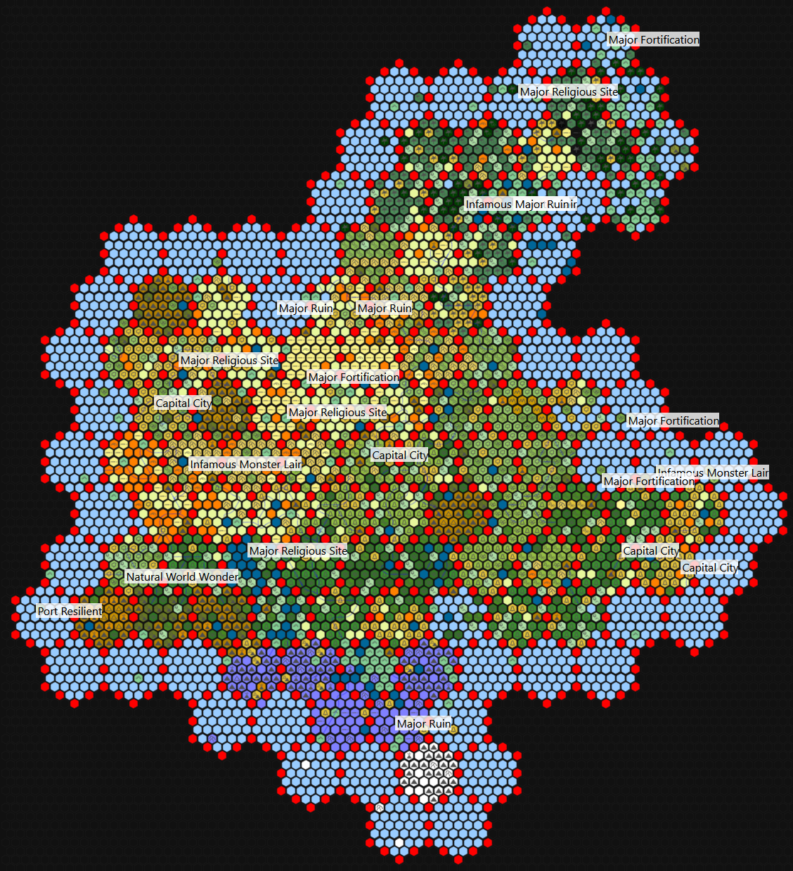
After mapping the rivers, copy your landmark locations over to the region-detail map. Choose a suitable region hex within the atlas hex boundaries for each landmark location. I dropped in their icons and put some text on the map to make them easy to locate. Below is a picture of where the continent is now!
Wrapping Up Continent Region Mapping
It was a lot of work but I’m quite happy with the result. But it’s not quite the final result. First I completed a clean version of the map by filling in the red border hexes. To do so I rolled 1d6 and filled the hex in with the corresponding hex biome along its border. As far as next steps, I need to key the entire continent with region-level POIs. That means more settlements, POIs, and Tier 3 (5e levels 11-16) adventure locations!
Keying the map will be a lot of work but also a lot of fun. I think it may be documenting that process online, maybe as a Twitch stream. So if you want to see that, make sure to follow me on Twitch. And if you missed the mapping streams or want to see what else we’ve got cooking it generally ends up on YouTube, so subscribe!
Thanks for reading, we’ve got more coming so stay tuned! If you’re like to support the work we do I’d appreciate it. You can support for FREE by sharing these blog posts and YouTube videos on Reddit or your favorite TTRPG forum. And if you would like to help keep the lights on, consider donating a dollar through Ko-Fi, or by paying for one of our PDFs on DriveThruRPG.
But, that’s it for me. And I’ll see you guys in the next one, bye!
Fantastic! I can’t overstate what an incredible resource your blog has been to my own world building and campaign preparations.
There is however one thing, one step, I haven’t quite understood about your procedure. I want to say I have studied every post from the region mapping section thoroughly, but I can’t seem to find how you’ve gone about distributing islands at the regional level before. I see that “The Gyre” is full of islands, but I don’t see by what process you’ve placed them there. They’re mentioned among POI examples, but it would make no sense for waters in heartlands/marches regions to hold more islands than wild stretches of water.
Thank you for all of your work!
Thanks very much for the kind words, glad you’ve found the information useful! I believe the information you’re looking for is noted in the 2d6 Biome Diversification section of the process. Rolling the 2d6 with a water primary hex should end with water for the majority of results. That said I think it IS actually more likely for there be a higher land/water ratio among inland lakes than the ocean. No hard evidence to back that up, just supposition given the much closer proximity from the water’s surface to bed/floor and more variable water levels.
But what may be helpful for you is checking out the RedRaggedFiend YouTube channel: https://www.youtube.com/@RedRaggedFiend. I’ve livestreamed working through the hex mapping process and I think it is a better source than a blog for answering these finnicky head scratchers!